


TUCSON, Ariz. — Monsoon has come to an end with a dull thud. 2020 has been a strange, unusual year and the weather is no different. We have come out of our hottest summer ever and now close the book on our 2nd driest monsoon ever in Tucson.
Officially, at the Tucson International Airport, Tucson received 1.62” of rain for monsoon. Remember, monsoon begins June 15th and ends September 30th. During that time, we usually receive 6.08” of rain. This year, in the month of September, we didn’t even get any measurable rain at the airport where official readings are taken. Here’s a breakdown of how much rain we received each month of monsoon…
June: 0.00” (June 15th – 30th)
July: 0.46” (10th driest July ever)
August: 1.16” (August is usually our most productive month with an average of 2.39” of rain)
September: 0.00” (The only other time we failed to record any measurable rain in the month of September was in 1953)

We started the year in fine shape with rain totals running over 2” above average thanks to some significant rainfall near the end of 2019. We now find ourselves running nearly 5 ½” below average for the year and monsoon certainly didn’t help.
This all adds up to what many of us are calling the “nonsoon” of 2020. Here’s a look at monsoon rain totals from around southeastern Arizona. Most locations were well below average…

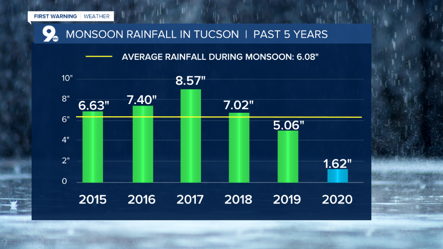
Taking a look back at the last 5 years of monsoon, we see that we had some pretty productive years until last year…
As bad as monsoon 2020 performed, we have seen some pretty lean years going back 100 years. We hear from many long-time southern Arizona residents that monsoon “used to be so much more active and bring so much more rain.” As we look back at the previous 10 decades, we find that it evens out quite a bit. We’ve had 5 decades of below-average monsoon rainfall and 5 decades of above-average monsoon rainfall. This means our current decade will be the tiebreaker.
A closer look at this graph shows our wettest monsoon years occurring in the 1950s, 1960s, and 1980s. Our wettest monsoon was in 1964 while our driest was in 1924. The 1970s and 2000s were weaker decades for monsoon performance. Remember, these numbers represent the average monsoon rainfall for each decade. So far, this decade has not started well. Hopefully, we’ll see a vast improvement over the next 10 years…

It is interesting to note, according to NOAA (National Oceanic and Atmospheric Administration), we had strong El Nino (warmer than average sea surface temperatures in the Eastern Pacific Ocean) years in 1982/83; 1997/98 and 2015/16. Other stronger years were in 1957/58; 1965/66; 1972/73; 1987/88 and 1991/92. Compared to the averages, El Nino didn’t seem to have a major impact on monsoon rain totals.
Strong La Nina (cooler than average sea surface temperatures in the Eastern Pacific Ocean) years occurred in 1973/74; 1975/76; 1988/89; 1998/99; 1999/2000; 2007/08 and 2010/11. When we compare these years to the averages, we find strong La Nina years were similar to El Nino years. There was no conclusive evidence to say whether La Nina had a significant impact on monsoon.
Suffice it say, monsoon 2020 will be remembered as a big disappointment. This is a major reason we had to endure the hottest summer ever. With a lack of moisture and rain, we didn’t get the cooling we usually enjoy in July and August. Instead, we got record heat!
The reason for the record heat was a big area of high pressure that sat over the Southwest for most of the summer and continues to dominate our weather as we go through fall. This pattern doesn’t show much sign of changing and will likely bring above-average temperatures and below-average rainfall through December. Also, it appears a weak La Nina will develop this winter. This usually results in drier than average conditions for the Southwest.

Lets hope we get a few storms to find their way into the Southwest and bring us the much-needed rainfall we all so desire!
