

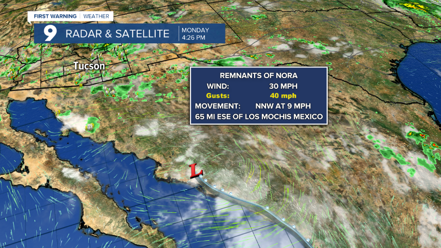
TUCSON, Ariz. (KGUN) — An abundant amount of moisture will be making its way across Arizona over the next two days and this will lead to the possibility of heavy rain and flash flooding. The moisture is a result of what was Hurricane Nora that made its way along the west coast of Mexico, over the Gulf of California and across Sonora.
RELATED
- Understanding monsoon and where all the rainwater goes
- Monsoon 2021 producing record rainfall
- Latest swift water rescue numbers
This moisture will combine with monsoon moisture already in place to produce slow moving showers and thunderstorms. Heavy rain falling on top of already saturated soil will enhance the potential for flash flooding. Flash Flood Watches go into effect Tuesday morning and will remain in effect through Wednesday night. These watches will cover much of the Southwest including all of Arizona.

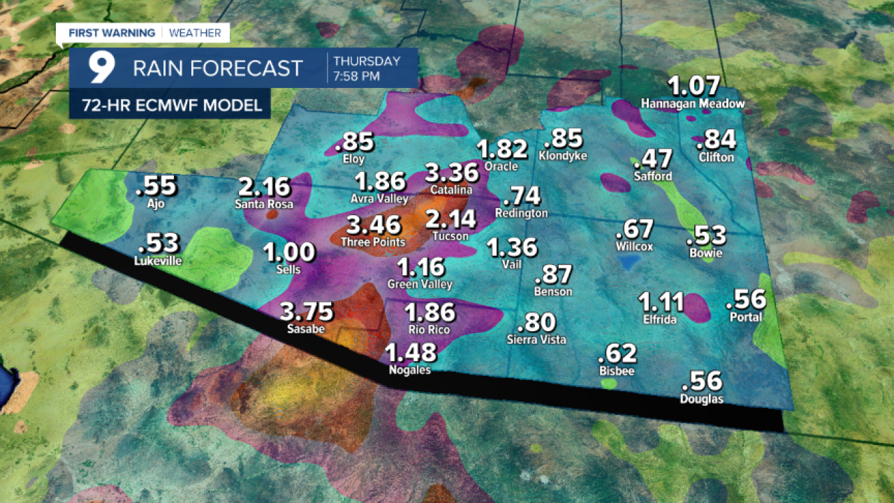
Rainfall forecast models are indicating some locations could receive over 3” of rain from Tuesday morning through Thursday evening. Some of the heaviest rain will south and west of Tucson. Even in the metro area, we could see up to 3” of rain in some neighborhoods.

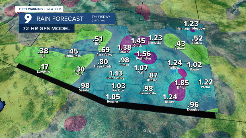
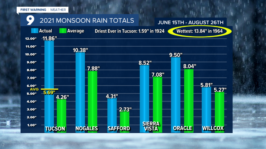
Even though we haven’t seen too much rain at Tucson International Airport in the last couple of weeks, we’re still doing quite well for official rain totals. In fact, in Tucson, we’re less than 2” away from breaking the old record for the wettest monsoon ever recorded! This next wave of moisture just might do the trick!
So far, in Tucson, we have recorded 11.89” of rain at the airport. The record for the all-time wettest monsoon is 13.84” and we still have a month of monsoon remaining along with a good chance of rain over the next few days and into the weekend.
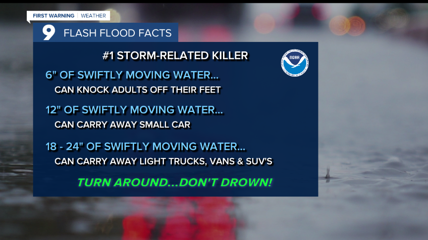
Flash flooding will be quicker to develop because we already have saturated soil throughout much of southern Arizona and even a half-inch of rain could cause flooding issues. Remember, according to the National Weather Service, flash flooding is still the #1 storm-related killer. Washes will likely be running and we’ll see plenty of ponding water on local roads and highways over the next couple of days.
Please be careful and pay close attention to the weather as this next wave of wet weather passes. We will closely monitor the potential flooding and keep you up to date on the latest advisories and warnings. Stay safe and enjoy the cooler temperatures that will accompany the rain!


